Plots, Paths and Playing Fields: The Green Ledger Heathrow Expansion Has Not Audited
The debate over Heathrow expansion is conducted in the currency of runways, passenger forecasts and carbon budgets. Those measures matter. But they can obscure a quieter account: the green infrastructure that makes neighbourhoods at the airport’s edge liveable. In 2026, as the expansion case is reassembled, that account still lacks a proper ledger.
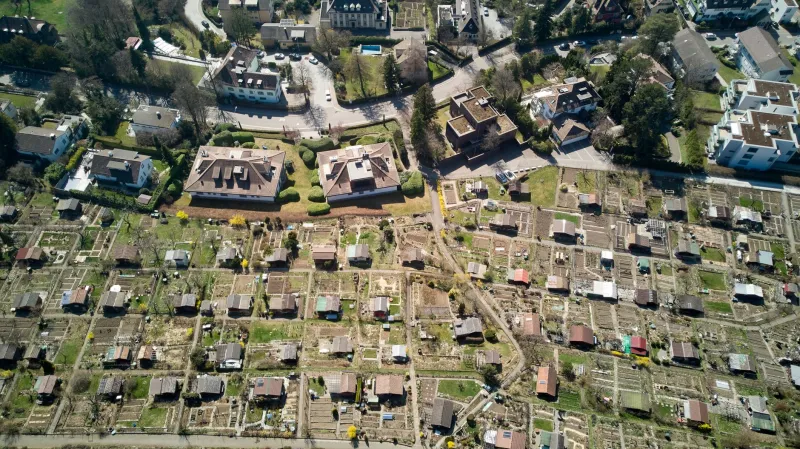
By green infrastructure we do not mean only the Colne Valley Park or the designated wildlife sites that appear in environmental statements. We mean the allotment colonies, community orchards, recreation grounds, playing fields, footpaths, canal towpaths, churchyards and verges that residents use every day. These are not decorative spaces. They are the places where children learn to cycle, where older residents take a safe walk, where households grow food, where surface water drains, and where neighbours meet without spending money.
For Heathrow’s neighbourhoods — Sipson, Harmondsworth, Harlington, Longford, Stanwell, Colnbrook, Poyle, Cranford and the fringes of Hounslow and Hillingdon — such spaces are scarce. The expansion debate has treated them as residual. A green space audit would put them at the centre of the question.
The everyday green estate
Statutory allotments are protected in law, but protection is not immunity. Playing fields with Fields in Trust status carry covenants, yet covenants can be moved, varied or traded away in the wider public interest. Public rights of way are recorded on the definitive map, but a diversion order can redraw a daily route. Village greens, local green spaces and neighbourhood plan designations all matter, but none of them is a guarantee against a project of national significance.
That is why a parcel-by-parcel audit is needed. The green estate at Heathrow’s edge is not one large site. It is a mosaic of small parcels, each with its own tenure, users and ecological function. Individually, a half-acre allotment site or a junior football pitch can look minor. Together, they form a network that makes the area habitable. Sever one path and the network loses more than the metres of tarmac involved.
A parcel-by-parcel method
The audit should begin not with a glossy map but with registers. The local authority’s allotment list, the definitive map of public rights of way, Fields in Trust records, local plan designations, neighbourhood plan policies, flood risk maps and the sites of special scientific interest or local wildlife sites nearby should all be laid alongside the airport’s expansion envelope.
For each parcel, the ledger should record: current use; legal status; tenure and users; access routes; ecological value; flood storage or drainage function; connectivity to other green spaces; and the risk of permanent loss, temporary construction damage or severance. That last category is often forgotten. A footpath can remain on a map while becoming unusable because a haul road crosses it, a fence blocks it or a construction compound makes it unsafe.
Residents have identified allotment sites around Harmondsworth and Harlington, recreation grounds in Sipson and Longford, and footpaths linking Stanwell to Colnbrook and the Colne Valley as particular concerns. The precise boundary of any expansion envelope matters enormously, which is why parcel-level disclosure is essential. Communities cannot test what they cannot see.
This is not an anti-development exercise. It is a test of whether the expansion case can account for what it removes. A project that cannot list the green spaces it would take, divide or degrade has not completed its homework.
What residents say
A plot-holder in Harmondsworth, who asked not to be named, described her allotment as a workplace, a pharmacy and a living room. She was not speaking metaphorically. The plot supplies food, exercise and company. The shed is where neighbours share tools and news. If the site goes, those functions do not reappear in a biodiversity offset several miles away.
A parent in Harlington said the local playing field is the only flat, free, safe space where her children can run without crossing a busy road. A walker in Longford described a footpath as the route that makes the school run possible without a car. These are ordinary testimonies, but they describe infrastructure as surely as a rail line does.
The gap in the consultation
Expansion documents tend to convert green space into biodiversity units, access metrics and compensation packages. Biodiversity net gain is necessary, but it is not sufficient. An off-site habitat bank cannot reproduce a ten-minute walk to an allotment. A cash payment cannot restore the social life of a community garden. A footpath severed by a runway embankment is not a biodiversity loss; it is a daily displacement.
The environmental statement for any expansion should contain a green infrastructure chapter, not a footnote. It should map the parcels, assess the functions, consult the users and publish the residual harm. It should distinguish between temporary construction impacts and permanent loss. It should say plainly what will be replaced, where, when and for whom.
Ten questions for communities
- Ask for parcel-level maps showing every allotment, playing field, community garden, footpath and green space inside and adjacent to the expansion envelope.
- Confirm the legal status of each parcel, including statutory allotment protection, Fields in Trust covenants, public rights of way and local green space designations.
- Request user surveys, not just visitor counts, so that the everyday value of spaces is recorded.
- Map access routes and ask how severance will be prevented during construction and after operation.
- Test flood storage and drainage functions, especially along the Colne and the Duke of Northumberland’s River.
- Check ecological connectivity, not only the presence of protected species.
- Ask whether replacement land will be provided locally, and whether it will be ready before any loss occurs.
- Demand a monitoring plan with community involvement and published results.
- Tie the expansion test to local plan and neighbourhood plan policies on health, recreation and green space.
- Ask the airport and the Planning Inspectorate to explain what happens if the replacement land fails.
Pause before the first turf
None of this is an argument against change in principle. It is an argument against change without an account. Heathrow Pause’s position is that a pause is not a refusal; it is a demand for evidence. The green ledger is part of that evidence. Before a third runway moves a single plane, it would move a great deal of ordinary life. Communities deserve to see the list before the turf is turned.